Villages in the Municipality
of Álamos, Sonora

Villages in the Municipality
of Álamos, Sonora

Despite it not being a largest community, since it only has 342 inhabitants according to the last census, El Chinal (whose name comes from the tree "Chino", which is abundant in the area, hence the chinal, as pine or olive grove) one of the most famous towns not only of the municipality, but of the state. To this fame has contributed not only the predominant physical characteristics of its inhabitants: white skin, light eyes, highlighting the beauty of the "chinaleñas"; but also the "hot dogs" that have spread, even to other states of the republic.
According to a file that is in the General Archive of the State of Sonora, on November 8, 1774, Mr. José Francisco Ezquerra de Rosas appeared before the authorities of the Real de los Alamos, requesting the extension of the property title of a large cattle site and twenty-three horses and stalls known as "Señor San José del Chinal.” To become creditor, he had to verify the possession of the lands, which he had acquired by donation of Mr. Julián de Samayoa. One the witnesses presented by Ezquerra, declared:
"Don Julián de Samayoa was the owner of these lands for having bought them from Don Nicolás de Acosta who owned them for many years and then Samayoa said that he had them for more than twenty-two years, now Don José de Rosas for more than two years without any contradiction. "
In a subsequent statement, it is noted that El Chinal was more than forty years "in quiet and peaceful possession", so we would go back to the year 1734 when it was first owned by Nicolás de Acosta, then, around 1754, it became property of Julián de Samayoa and in 1772 he donated it to Juan de Ezquerra y Rosas.
Of the quality of the lands, the appraisers pointed out:
"Having recognized the measured land and its quality, the main thing is the lack of water, because by boot strength it keeps its assets and also water is scarce because although it has pasture it has the defect that the beasts are peeled and the hulls fell to the foals with few planting lands, so considering all this, these lands were valued at ten times the largest cattle and the twenty-three caballerias of land plus six pesos that is sixteen pesos, which is how much it can be worth.” Here we can see the constant need for the vital liquid, water, in which the region has lived.
Thus, on June 28, 1775 was granted by the Real Audiencia de Guadalajara, with a fee of 50 pesos, the title deed, which indicates the boundaries: the east with the position of Bullubampo; on the north with the post of Cuevas y Maquipo; by the west with the Ciénega and by the south with Bacamaya.
Ten years later, on December 14, 1785, Don José Ezquerra de Rosas appeared, with the consent of his wife, María Gertrudis de Avilés: "who hereby grants and knows that he sells currently and with effect from now for ever and ever Francisco Mendívil, also neighbor of this Real saying for him, his heirs, his successors [...] is to know the place of the Chinal for greater livestock, under its limits and boundaries that consist his measures with title and royal approval [...] ". He sells it in "300 pesos free of writing and alcababa, the 250 that he has given and has received at his will and satisfaction and the remaining fifty that he has to rebate in real effects for the whole next year of 86".
As Mr. Ezquerra had lost the titles of property, Mr. Francisco Mendívil requested them in 1786 to the Real Audiencia de Guadalajara, a long and cumbersome procedure due to the difficulty of communications, since he had to request them to Guadalajara and pay the costs in Arizpe; thus, it was not until February 25, 1793, that he was granted the property title, which he considered an area of 2, 746 hectares.
On the death of Francisco Mendívil, who was not French or Italian as has been said, but a descendant-perhaps great-grandson-of Captain Pedro Martínez de Mendívil, one of the first inhabitants of Álamos (it appears in the records of the 1680s), the ranch would pass to his heirs, so the land report of the Álamos district of 1893 states that El Chinal was owned by "Mendívil Hermanos".
By the beginning of the 20th century, the community had its own school and, towards the second decade of the mentioned century, the temple dedicated to the patron saint San Isidro Labrador (which strangely is not San José) was built, to whom the solemn feast was made. 15 th of May. Subsequently, by decree of April 13, 1935, it rose to the category of police station, years in which its population was around 600 inhabitants.
Currently, as indicated at the beginning of the text, the community has a population of 342 people, has all the basic services, has a beautiful temple (which has the status of a fixed vicarage or quasi-parish, with the continued presence of a deacon who imparts the sacraments to the population, which stands out for its high religious fervor), a plaza with kiosk, cemetery, schools of the three levels: preschool, primary and secondary, since the high school is located in the neighboring community of El Maquipo, four kilometers away.
The Chinal is located in the south of the municipality in the vicinity of Sinaloa, 57 kilometers from the municipal seat with which it communicates with a dirt road that passes through other relevant communities. Among his most known and common surnames we have, of course, Mendívil, as well as Carballo, Rosas, Domínguez and Félix.
On the occasion of the 213 anniversary of the purchase of El Chinal by Francisco Mendívil, on December 19, 1998, the community became a municipal seat for a day, a title that he held from 7 in the morning until 11 at night. cited day, this with authorization from the Congress and the State Executive, through a decree published in the Official Gazette.
We already said at the beginning, that one of the most famous features of the place are the hot dogs, a business that according to Bulmaro Pacheco, started among the people of China at the initiative of Héctor Félix, who worked in the hot dog cars of Armando Bours in Navojoa in the 1970s. Thus, writes Pacheco:
"Gradually and in less than 30 years, the micro-enterprises of the hot dogs that start from the Chinal have supported more than a thousand native families that are located in a large part of the state of Sonora, Sinaloa, part of Chihuahua and in some parts of Arizona. . They have contributed significantly to improving the income of the population and have reflected it into their community through greater well-being of families based on the solidarity of seeing each other, precisely; like a big family. "
A pesar de no ser de las comunidades más grandes, pues tan solo cuenta con 342 habitantes según el último censo, El Chinal (cuyo nombre proviene del árbol “Chino”, el cual es abundante en la zona, de ahí el chinal, como decir pinar u olivar) una de las poblaciones más famosas no solamente del municipio, sino del estado. A esta fama ha contribuido no sólo las características físicas predominantes de sus habitantes: piel blanca, ojos claros, destacando la belleza de las “chinaleñas”; sino también los “hot dogs” que se han extendido, incluso, a otros estados de la república.
Según un expediente que se encuentra en el Archivo General del Estado, el 8 de noviembre de 1774 se presentó ante las autoridades del Real de los Álamos el señor José Francisco Ezquerra de Rosas, solicitando se le extendiera título de propiedad de un sitio de ganado mayor y veintitrés caballerías del puesto conocido como “del Señor San José del Chinal”. Para hacerse acreedor de esa merced, hubo de comprobar la posesión de las tierras, las cuales había adquirido por donación del señor Julián de Samayoa, uno los testigos presentados por Ezquerra, declaró:
“Don Julián de Samayoa fue dueño de dichas tierras por habérselas comprado a don Nicolás de Acosta quien las poseyó muchos años y después dicho Samayoa que a más tiempo de veintidós años las tuvo, ahora don José de Rosas a más de dos años sin contradicción alguna”.
En una declaración posterior, se señala que El Chinal tenía más de cuarenta años “en posesión quieta y pacífica”, por lo que nos remontaríamos al año 1734 cuando lo poseyó su primer dueño Nicolás de Acosta, luego, alrededor de 1754, pasó a propiedad de Julián de Samayoa y en 1772 se lo donó a Juan de Ezquerra y Rosas.
De la calidad de las tierras, lo valuadores señalaron:
“Habiendo reconocido la tierra mesurada y su calidad de ella lo principal la falta que es el agua pues a fuerza de bota mantiene sus bienes y que también el agua se escasea pues aunque tiene pastos tiene el defecto de que se pelan las bestias y se le caigan los cascos a los potrillos con pocas tierras de siembra, por lo que considerando todo esto avaluaban estas tierras en diez el sitio de ganado mayor y las veintitrés caballerías de tierras más en seis pesos que son dieciséis pesos que es cuanto puede valer”. Aquí podemos ver la constante necesidad del vital líquido en la que ha vivido la región.
Así, el 28 de junio de 1775 se le otorgó por parte de la Real Audiencia de Guadalajara, con una cuota de 50 pesos, el título de propiedad, donde se señala las colindancias: por el oriente con el puesto de Bullubampo; por el norte con el puesto de Cuevas y Maquipo; por el poniente con la Ciénega y por el sur con Bacamaya.
Diez años después, el 14 de diciembre de 1785, compareció don José Ezquerra de Rosas, con consentimiento de su esposa doña María Gertrudis de Avilés: “que por la presente otorga y conoce que vende realmente y con efecto desde ahora para siempre jamás a don Francisco Mendívil, asimismo vecino de este dicho Real para él, sus herederos, su sucesores […] es a saber el sitio del Chinal para ganado mayor, bajo sus límites y linderos que constan sus medidas con título y merced Real […]”. Se lo vende en “300 pesos libres de escritura y alcabala, los 250 que le tiene dados y ha recibido a su voluntad y satisfacción y los restantes cincuenta que le ha de bonificar en efectos reales para todo el próximo año de 86”.
Como el señor Ezquerra había perdido los títulos de propiedad, el señor Francisco Mendívil los solicitó en 1786 a la Real Audiencia de Guadalajara, un trámite largo y engorroso por la dificultad de comunicaciones, pues había de solicitarlos a Guadalajara y pagar las costas en Arizpe, así, no fue sino hasta el 25 de febrero de 1793 que se le otorgó el título de propiedad, que consideraba una superficie de 2 746 hectáreas.
A la muerte de Francisco Mendívil, que no era francés o italiano como se ha dicho, sino descendiente –quizá tataranieto- del capitán Pedro Martínez de Mendívil, uno de los primeros habitantes de Álamos (aparece en los registros de la década de 1680), el rancho pasaría a sus herederos, así es que el reporte de tierras del distrito de Álamos de 1893 señala que El Chinal era propiedad de “Mendívil Hermanos”.
Ya para principios del siglo XX, la comunidad contaba con su propia escuela y hacia la segunda década de la mencionada centuria se construyó el templo dedicado al santo patrón San Isidro Labrador (que extrañamente no es San José), a quien le hacen solemne fiesta el 15 de mayo. Posteriormente, por decreto del 13 de abril de 1935, se elevó a categoría de comisaría, años en que su población rondaba los 600 habitantes.
Actualmente, como se señaló al inicio del texto, la comunidad tiene una población de 342 personas, cuenta con todos los servicios básicos, tiene un bello templo (que tiene la categoría de vicaría fija o cuasi-parroquia, con la presencia continua de un diácono que imparte los sacramentos a la población, la cual se destaca por su elevado fervor religioso), una plaza con kiosco, cementerio, escuelas de los tres niveles: preescolar, primaria y secundaria, ya que la prepa se encuentra en la vecina comunidad de El Maquipo, distante cuatro kilómetros.
El Chinal se localiza en el sur del municipio en las colindancias con Sinaloa, a 57 kilómetros de la cabecera municipal con la que se comunica con una carreta de terracería que pasa por otras comunidades de relevancia. Entre sus apellidos más conocidos y comunes tenemos desde luego Mendívil, así como Carballo, Rosas, Domínguez y Félix.
Con motivo del 213 aniversario de la compra de El Chinal por parte de Francisco Mendívil, el 19 de diciembre de 1998 la comunidad se convirtió en cabecera municipal por un día, título que ostentó desde las 7 de la mañana y hasta las 11 del noche del citado día, esto con autorización del Congreso y del Ejecutivo del Estado, a través de un decreto publicado en el Boletín Oficial.
Ya lo decíamos al inicio, que una de las características más famosas del lugar son los hot dogs, negocio que según Bulmaro Pacheco, inició entre los chinaleños por iniciativa de Hétor Félix, quien trabajó en los carros de hot dog de Armando Bours en Navojoa en la década de 1970. Así, escribe Pacheco:
“Gradualmente y en menos de 30 años, las microempresas de los hot dog que parten del Chinal han apoyado a más de mil familias originarias que se ubican en gran parte del estado de Sonora, Sinaloa, en parte de Chihuahua y en algunos lugares de Arizona. Han contribuido notablemente a mejorar el ingreso de la población y lo han reflejado hacia el interior de su comunidad a través de un mayor bienestar de las familias basado en la solidaridad de verse todos, precisamente; como una gran familia”.
El Chinal
by Juan Carlos Holguín Balderrama, Álamos city historian
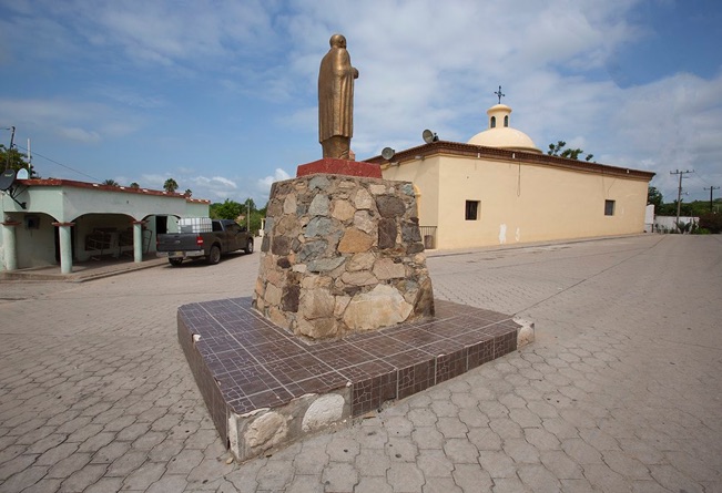
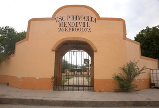
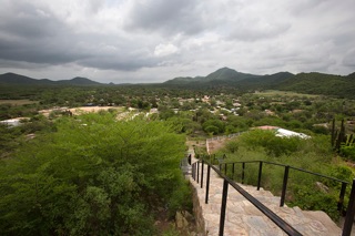
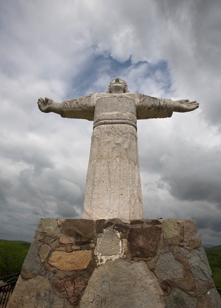
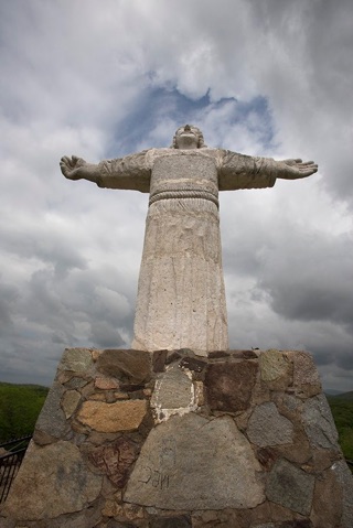
TOP: The main plaza with its statue of Benito Juárez. ABOVE LEFT: The Christ the King statue overlooking the community. ABOVE RIGHT: A view of the community and the elementary school. photos©Errol Zimmerman, 2019
Las Plomosas
by Juan Carlos Holguín Balderrama, Álamos city historian
En el Archivo General del Estado se localiza un expediente de solicitud de título iniciada en 1834 por el señor Pedro Ignacio García, quien en dicho documento señala que el compró el rancho Las Plomosas el 3 de marzo de 1810 a don José Esquer y don José María Ávila, pero que nunca los había titulado a su nombre. Los antecedentes de posesión del expresado rancho se remontan a fines del siglo XVIII, pues en el citado expediente se asienta que don Tomás Pelayo, subdelegado de Álamos, midió el predio el 28 de marzo de 1798 a petición de don Prudencio Ruiz de Eguino, resultando una superficie de tres sitios y veinticinco caballerías. Los sitios fueron valuados a tres pesos cada uno “en razón de que todos se componen de lomas, montes intransitables y no tienen tierras de panllevar”, no obstante el agrimensor Pelayo no se conformó con ese avalúo y elevó el precio a cinco pesos por sitio “por que así le pareció justo [debido a que] tiene bastante agua, buenos potreros y sus correspondientes sombríos”. Dado que las posesiones, tanto de Esquer y Ávila como luego la de García, se habían realizado de manera pacífica, el gobierno del estado resolvió titular a nombre de éste último el sitio conocido como Las Plomosas el 20 de diciembre de 1836, con una superficie de
6,828 hectáreas.
Las Plomosas se localiza aproximadamente a hora y media, aguas arriba por el arroyo Cuhujaqui, del Sabinito Sur (el cual se encuentra a doce kilómetros de Álamos, distancia que toma alrededor de media hora recorrer), a donde se accede por un accidentadísimo camino de terracería. Según el censo de 2010, la localidad cuenta con 42 habitantes, los cuales en su mayoría no tienen agua potable entubada, ni drenaje, ni luz eléctrica, por lo que el INEGI lo considera un poblado con alto grado de marginación.
En 2012 tuve la oportunidad de conocer personalmente el lugar, un ranchito bello en paisaje con cerros y lomeríos, arroyos, extensos montes y un cielo limpísimo como todos los del municipio, pero sin casa de salud, cancha deportiva, ni escuela como tal, pues los niños tomaban clases en un armazón de horcones y palos con techo de hule negro, pero, me dijo una mujer, “un día que hizo mucho viento tumbó y trozó el hule”, por lo que cuando yo visité la localidad se les impartía clases bajo un mezquite sentados sobre llantas. En esa ocasión se realizó un mitin político en el lugar, se reunieron alrededor de 25 personas ya que el resto andaba para otros ranchos y unos habían “bajado a Álamos”. Una señora de algunos 75 años fue una de las que dio la bienvenida y estaba “azorada” (según dijo), porque nunca había visto algo así en Las Plomosas, dijo tener cincuenta años viviendo ahí y jamás un candidato había hecho campaña en el lugar. La reunión fue en el llano-escuela que, según comentaron, madrugaron a barrerlo lo cual era evidente dada la esmerada limpieza del lugar que lo hacía lucir acogedor.
Hago mención esto porque nos brinda, creo, un reflejo de la situación que viven muchas personas de nuestro municipio, situaciones que la mayoría de las veces ignoramos encandilados con la “magia” y belleza de nuestra ciudad, sin percibir que Álamos no se limita a la Ciudad de los Portales sino a todo el extenso territorio del municipio. Desconozco qué estado guarde actualmente la localidad de Las Plomosas, debido a que los datos que pude conseguir a través del INEGI se basan en los censos de 2005 y 2010, pero sé que en 2016 se les hizo finalmente entrega de un aula para la escuela primaria con todo lo necesario que tanta falta hacía.
In the general archive of the state is located a file of application of title started in 1834 by Mr Pedro Ignacio García, who in that document points out that he bought the rancho Las Plomosas on March 3, 1810 from Don José Esquer and Don José María Ávila, but who had never titled them to his name. The background of possession of the expressed ranch dates back to the end of the 18th century, for in the aforementioned record it is states that Don Tomás Pelayo, a citizen of Álamos, measured the property on March 28, 1798, at the request of Don Prudencio Ruiz de Eguino, resulting in a surface of three sites and twenty-five horses. The sites were valued at three pesos each "because they are all made up of hills, impassable mountains and have no land of cultivation", however the surveyor Pelayo did not settle with that value and raised the price to five pesos by the site "because so it seemed fair [ because it ] has enough water, good pastures and is correspondingly gloomy.” Since the possessions, both of Esquer and Ávila and then that of Garcia, had been carried out peacefully, the government of the state ruled holder in the name of the latter the site known as Las Plomosas on December 20, 1836, with an area of 6, 828 hectars.
The Plomosas are located about an hour and a half, waters arriving from the arroyo Cuhujaqui, from the south of Sabinito (which is located 12 kilometers from Álamos, a distance that takes about half an hour to go), where it is accessed by an nearly impassable path of Land. According to the 2010 Census, the town has 42 inhabitants, which mostly do not have drinking water, or drainage, or electric lights, so INEGI considers it a village with A high degree of marginalization.
In 2012 I had the opportunity to personally see the place, a beautiful ranchito with a landscape with hills and hillsides, streams, extensive mountains and a clean sky like all of the municipality, but no clinic, sports court, or school as such , for the children took classes in a frame of plants and sticks with a black tarp roof, but, a woman told me, "one day a lot of wind knocked down the piece the rubber", so when I visited the town I taught them classes under a mesquite while sitting on tires. On that occasion a political rally was held in the place. They gathered around 25 people since the rest were from other ranches and some had gone "down to Álamos.” A lady of some 75 years was one of those who gave the welcome and was "awkward" (she said), because she had never seen something like this in Las Plomosas. In fifty years of living here, never had a candidate campaigned in the place. The meeting was in the make-shift school that, she commented, she had risen early to sweep— which was evident given the meticulous cleaning of the place that made it look cozy.
I mention this because it gives us, I believe, a reflection of how many people live in our municipality, situations that most of the time we ignore due to the "Magic" and beauty of our city, without perceiving that Álamos is not limited to The City of the Portales but to all the extensive territory of the municipality. I do not know the current state of the town of Las Plamosas, because the data I could get through INEGI are based on the censuses of 2005 and 2010—but I know that in 2016 they were finally given an elementary school classroom with many school supplies.
_______________________________________________________________________________
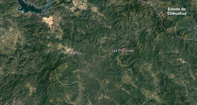
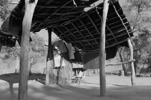
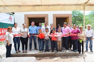
TOP: A map showing both Álamos and Los Plomosas. BOTTOM: Two photos showing the old school, and the inauguration of the new school in 2016. Photos provided by Juan Carlos Holguín Balderrama
GO TO:
Myths in Álamos History
https://alamoshistoryassociation.org/50.63.41.1/Myths_in_Alamos_history.html